

9 AM to 7 PM Monday-Saturday
+91-9251896140 (Sales)
+91-9251896143 (Technical)
+91-9166273732(HR)/hr@raynas.co.in

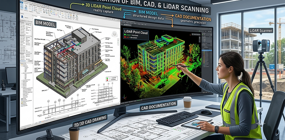
CAD & BIM with LiDAR Near me in Chandigarh Terrestrial Laser Scanning,Mobile LiDAR Scanning
CAD and BIM integrated with LiDAR technology have transformed the architecture, engineering, and construction (AEC) industry by enabling highly accurate digital representations of real-world environments. LiDAR uses laser pulses to capture millions of data points, creating a dense point cloud that reflects the exact geometry of structures, landscapes, and infrastructure. This point cloud data serves as the foundation for CAD drawings and BIM models, reducing reliance on manual measurements and minimizing errors. In renovation, expansion, and retrofit projects, LiDAR-based workflows help professionals obtain precise existing-condition information, even when original drawings are unavailable or outdated. CAD software converts captured data into detailed technical drawings, while BIM platforms create intelligent 3D models containing both geometric and asset-related information. The combination of these technologies significantly improves project planning, design accuracy, stakeholder collaboration, and overall project efficiency throughout the entire building lifecycle.
One of the primary applications of CAD and BIM with LiDAR is the Scan-to-BIM process, where laser-scanned data is transformed into a comprehensive digital building model. The workflow begins with terrestrial, mobile, or drone-based LiDAR scanning, followed by point cloud registration, cleaning, and processing. Once the point cloud is optimized, modelers use BIM software such as Autodesk Revit to recreate architectural, structural, and MEP components. Unlike traditional modeling methods, Scan-to-BIM provides a highly accurate representation of existing conditions, enabling better design decisions and reducing costly modifications during construction. This process is particularly valuable for heritage preservation, facility upgrades, and industrial plant modernization projects. By providing reliable geometric information and supporting clash detection, BIM models derived from LiDAR scans facilitate improved coordination among architects, engineers, contractors, and facility managers, ultimately streamlining project execution and enhancing construction quality.
LiDAR-driven CAD workflows play a crucial role in creating accurate engineering documentation and design deliverables. After collecting spatial data, engineers extract floor plans, elevations, sections, utility layouts, and infrastructure drawings directly from the point cloud. This method significantly improves productivity compared to conventional surveying techniques, as millions of measurements can be captured within a short period. CAD professionals can use the scanned data to model complex geometries, verify dimensions, and generate construction-ready documentation with greater precision. In large industrial facilities, manufacturing plants, and transportation projects, LiDAR-assisted CAD modeling helps identify existing equipment locations, structural elements, and utility networks before new designs are developed. As a result, project teams can reduce field visits, minimize design conflicts, and improve decision-making. The ability to maintain accurate as-built records also supports future expansions, maintenance activities, and operational planning initiatives.
CAD & BIM with LiDAR Near me in Chandigarh, CH | RAYNAS GEOMATICS
CAD & BIM with LiDAR Near me inChandigarh, CH.Workflow for design, and asset management Scan to CAD,LiDAR to CAD Conversion,Point Cloud to CAD,LiDAR BIM Modeling,Mobile Laser Scanning
CAD & BIM with LiDAR Near me in Chandigarh, CH.|Terrestrial Laser Scanning,Mobile LiDAR Scanning
The integration of LiDAR with BIM is becoming increasingly important in the development of digital twins and smart infrastructure solutions. Digital twins are dynamic virtual representations of physical assets that continuously support monitoring, analysis, and operational management. LiDAR provides the accurate spatial foundation needed to create these digital environments, while BIM contributes detailed asset information and lifecycle data. Together, they enable facility owners and operators to visualize asset performance, manage maintenance activities, and plan upgrades more effectively. In sectors such as airports, hospitals, industrial complexes, railways, and smart cities, digital twins powered by BIM and LiDAR improve operational efficiency and support data-driven decision-making. The addition of technologies such as Artificial Intelligence (AI), IoT sensors, and cloud computing further enhances these capabilities, allowing organizations to anticipate maintenance requirements, optimize resources, and improve long-term asset performance.
